The Morning Glory: The Cloud You Can Surf
Imagine standing in the flat red emptiness of northern Australia just before sunrise. The air is dead still. Then, along the entire horizon, a single smooth tube of cloud appears — a perfectly rolled cylinder, gliding toward you like a wave that decided to leave the ocean and try the sky. It can be a thousand kilometres long. It rolls overhead, the wind kicks up out of nowhere, and then it's gone, with maybe a dozen more lined up behind it. This is the Morning Glory, and it is one of the few clouds on Earth you can predict, chase, and even surf.
A wave that forgot it was supposed to break
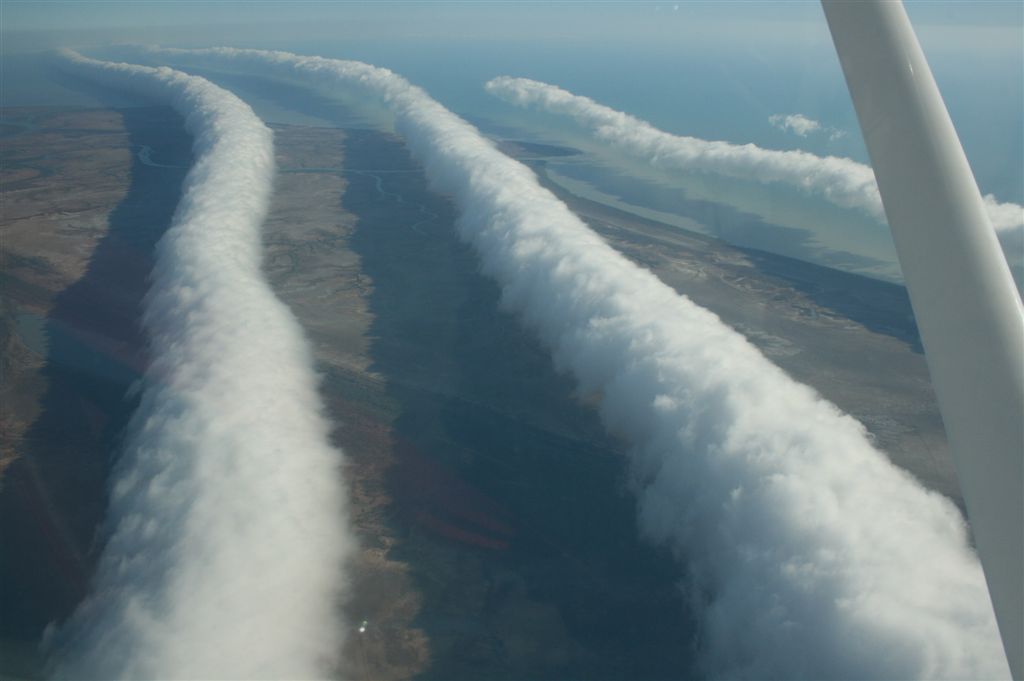
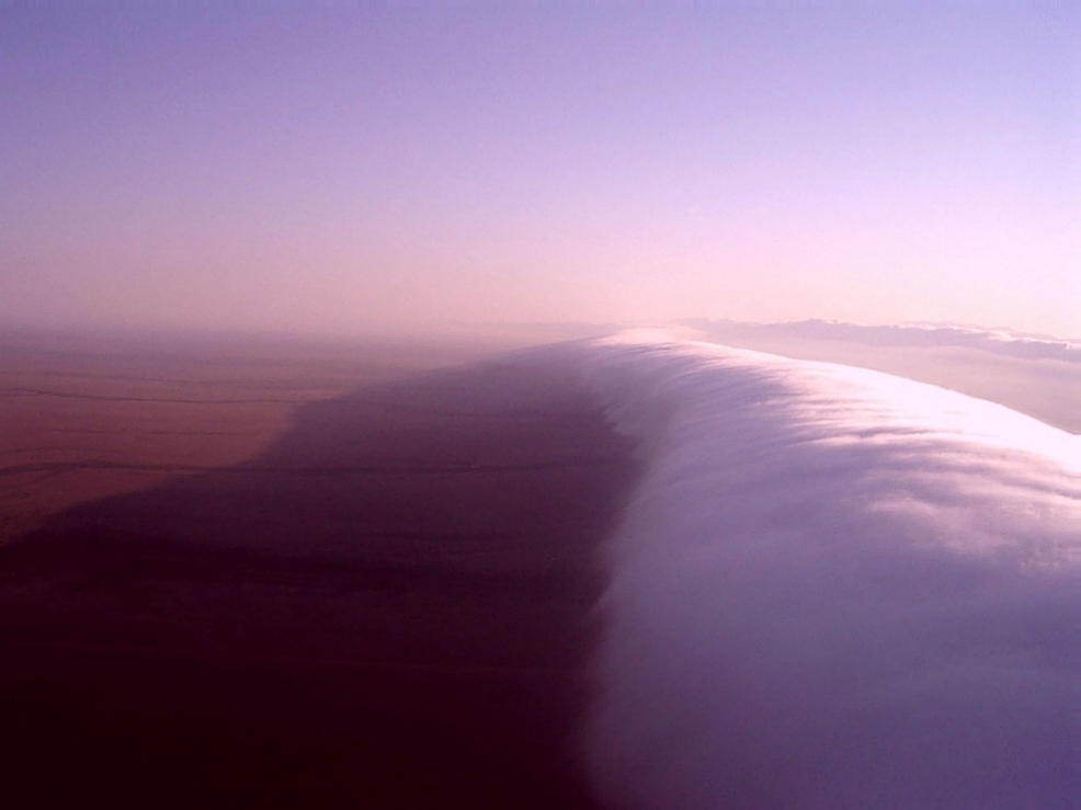
Most clouds are blobs. The Morning Glory is a line — a long, low, eerily clean cylinder of cloud that rolls along its own axis as it moves. It can stretch up to 1,000 kilometres across the horizon, stand 1 to 2 kilometres tall, and yet hang astonishingly low, with its base often just 100 to 200 metres off the ground. It moves at roughly 10 to 20 metres per second, which is 35 to 70 km/h — a brisk, silent advance across a landscape that, moments earlier, had no wind at all.
What you're actually looking at is a soliton: an atmospheric solitary wave. A normal ocean wave rises, crests, and collapses. A soliton is the rare kind of wave that holds its shape and keeps travelling for hundreds of kilometres without falling apart. In the Morning Glory, the air rises sharply at the front of the rolling cylinder — cooling and condensing into that crisp white tube — then sinks again at the back, where the cloud evaporates. The cloud isn't being carried along like smoke. It's constantly being rebuilt at the leading edge and erased at the trailing one, so the tube appears to roll forward while the water droplets inside it are merely passing through.
Why Burketown, and why spring
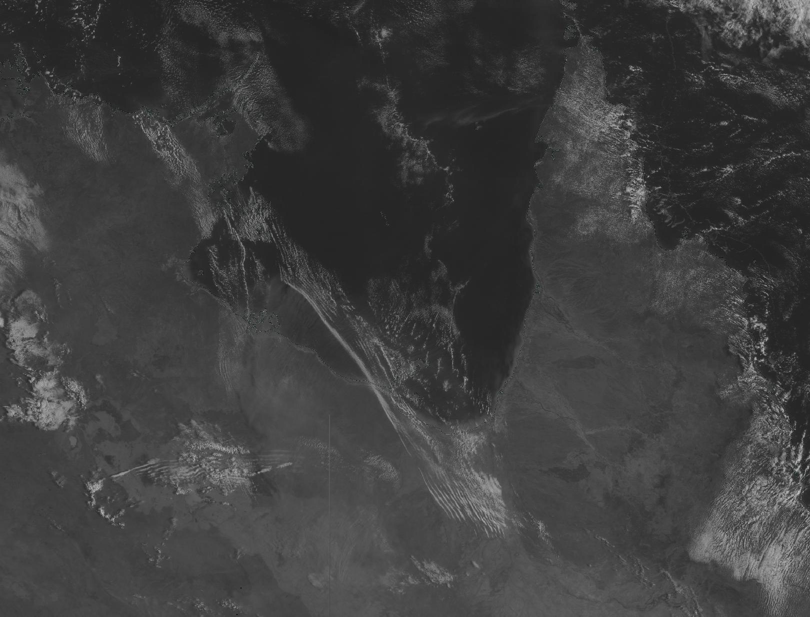
Morning Glories have been spotted from the English Channel to the central United States, but there is exactly one place on the planet where they show up often enough to plan a trip around: the southern shore of the Gulf of Carpentaria, near the tiny outback town of Burketown, Queensland. The window is narrow — roughly late September to early November, the tail end of the dry season.
The recipe needs a very specific kitchen. By day, sea breezes sweep in from both coasts of the Cape York Peninsula and collide. Overnight, a temperature inversion forms — a lid of warm air sitting on cooler air near the ground. The collision pushes a disturbance into that stable layer, and because the geography of the gulf funnels everything just so, the disturbance organises into a clean solitary wave that rolls out across the water and arrives over Burketown at dawn. It's a genuinely fragile alignment of land, sea, and temperature, which is why nowhere else can offer it on schedule.
The people who surf the sky
Here's where it gets wonderful. That sharp updraft at the front of the wave is, to a glider pilot, an invisible escalator made of moving air. Catch the rising face of a Morning Glory and you can ride it for hundreds of kilometres without an engine, soaring along the leading edge exactly the way a surfer rides the unbroken shoulder of a wave.
Every spring, a small, slightly obsessed community of glider pilots descends on Burketown to do precisely this. It is difficult, dawn-dependent, and there's no guarantee the cloud will even show. One gliding-club regular put the rarity perfectly: more people have stood on the summit of Everest than have flown the Morning Glory. To launch into still pre-dawn air, find that one moving wall of cloud, tuck up against its rising face and let it pull you silently across the outback — that is about as close as a human gets to surfing the atmosphere itself.
A name older than the science
Long before meteorologists had words like soliton and inversion layer, the people of this country knew the cloud intimately. The local Garrwa people called it kangólgi. They watched it arrive each spring across the same gulf, read it as a marker of the season, and understood its rhythm centuries before anyone tried to model it with fluid dynamics.
The cloud that keeps its shape
What lingers about the Morning Glory isn't just that it's beautiful, or rare, or surfable. It's that it shouldn't really exist. Waves are supposed to break. Energy is supposed to spread out and fade. A disturbance in the air should smear into nothing within minutes. Instead, this one gathers itself into a thousand-kilometre cylinder and rolls intact across an entire gulf, arriving punctually at dawn like it has somewhere to be.
So if you ever find yourself in Burketown in October, set an alarm for before sunrise and look to the east. With a little luck, you'll watch the sky do something it has no business doing: hold a wave together long enough for you to see it — and, if you're very lucky and slightly mad, to ride it.